Isaac is still a ragged storm. We are so accustomed to looking at tropical systems on satellite and we marvel at their beautiful structure and the "swirling" pattern they're noted for. Isaac isn't considered to be one of those. It's structure looks mangled due to dry air being pulled in the south end, but don't count him out with his strength!
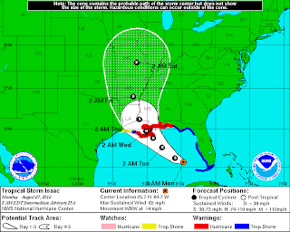
The storm should be intensifying today as moves into the open waters of the Gulf. Aircraft reconnaissance flights will continue to get the most accurate reading on it's cycles of growth. Here is the latest track for Isaac.
At this point, Isaac looks to make landfall along Grand Isle, Louisiana late Tuesday night and early Wednesday morning (before sunrise). This will dramatically slow the storm's forward speed. Early Thursday morning (before sunrise), the storm will move over Wilkinson County (Woodville area) and continue to move over Natchez and just west of Vicksburg before the remnants move into southern Arkansas and east central Missouri this weekend.
Everyone keeps asking, "What can my area expect?" So let me break it down a bit.
If you live south of I-20 and west of I-55 (that's the southwestern quadrant of Mississippi), you can expect tropical storm force winds, with higher gusts, for 36 hours. This will also come with heavy rain bands and the threat of tornadoes. Power outages can be expected due to the expansive winds and the power outages may last for a few days.
If you live north of I-20 and east of I-55, expect gusty winds, heavy rain, and quick spin up tornadoes. Power outages can be expected although may be more scattered, especially in rural areas.
If you live on the Mississippi Gulf Coast, expect hurricane force winds, beach erosion, heavy rain, a storm surge of 10-15 feet and tornadoes late Tuesday and early Wednesday as the storm makes landfall. Evacuate now!
Rainfall amounts from Isaac for Mississippi could top 5"-10". If you live in a low lying area prone to flooding, you need to head for higher ground.
This map shows the winds expected.
As always, I suggest you have your gas tank full, generators fueled up, your cell phones fully charged, cash money on hand that can last for at least 3-5 days, and plenty of water for your family and non-perishable foods to last for 3-5 days. It may be that long for the areas hardest hit to begin to have power restored. Make sure you have a NOAA Weather Radio with the battery backup so you can get immediate weather information should you lose electricity. And by all means, you common sense and civility!
No, Isaac will not be as strong as Katrina, but we've learned quite a bit about preparation since then and it's been 7 years since our state was hit with a hurricane. We'll get through this one together, too.
I will be on WLBT for the duration of Isaac, so we'll keep you updated.


